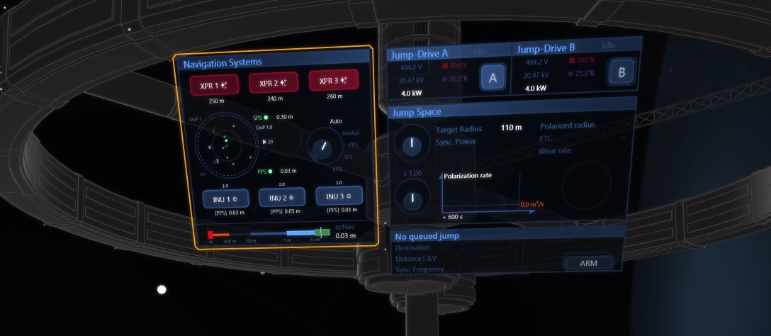
The navigation signal represents the data from the positioning sensors and that is used as reference by the flight control systems.
Prior to this update the ship’s computers were just passed perfect information from the underlying simulation engine, with a bogus system that was faking an abstract “navigation error level”.
This is not the case anymore and the ship now derives its location from 3 sources:
- Proximity Positioning System: high-precision (3 cm) radio navaid around stations for approach and docking phases,
- Space Positioning System: = GPS! The model includes “dilution of precision” effects i.e. how the relative position of the satellites as seen from the receiver degrades the intrinsic accuracy ~30cm,
- X-Ray Pulsar Receivers: a natural GPS system graciously offered by the universe 🙂 (precision around 200 m but after several hours of integration time).
And importantly these sensors are not perfect and compute the ship’s position with errors that are fed to the flight controller. From the gameplay standpoint:
- high-precision flying requires to setup the comms units,
- the ship feels less “on rails” that it used to (in the locations without SPS service),
- there are choices to make when configuring the jump-drive, with a trade-off between the equipment’s wear and a risk of jump failure.
The system is demonstrated in the following video: