Navigation Errors

The precision of all positioning sensors is limited and their output can be expressed as:

PNAV = PTRUE + εPNAV where εPNAV is the position error signal.

εPNAV is considered a random signal (i.e. “noise”) although its characteristics are generally closely related to deterministic characteristics from the sensors themselves (systematic delays, processing biases…) or the configuration of the position computation problem (conformation of a satellites’ constellation …).
As such it is quantified using its rms scalar value (root-mean-square) that can be interpreted as a probability. In a rough first approximation the chances that PNAV is within:

  • 1 x εPNAV rms of PTRUE = 68%
  • 2 x εPNAV rms of PTRUE = 95%
  • 3 x εPNAV rms of PTRUE = 99.7%

In relation to jumps

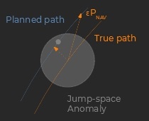
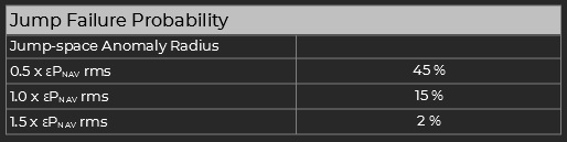
A jump occurs whenever the jump-point enters a correctly modulated anomaly bubble. Therefore a jump may fail if the navigation error is too large.

However the perpendicular component to the flight path is the only one that matters for the particular problem. Statistically this gives a [2/π] multipler on the effective position error for jumps, and the following table:


Velocity error

Over long periods of time the position error remains bounded in relation to εPNAV rms and does not accumulate over time. That is in first approximation εPNAV = constant and therefore its first derivative εVNAV ∼ zero.

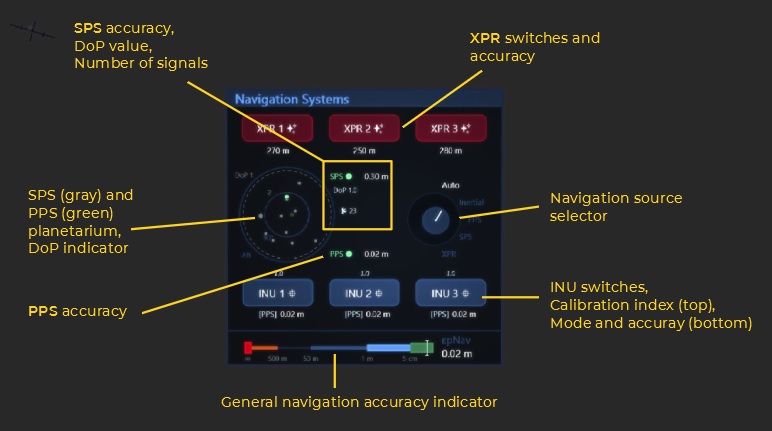
Radio Navigation Aids

The signals from nearby radio navaid emitters constitute the primary source of positioning information. They are received through dedicated comms units slots, and then processed by the comms controller.

Proximity Positioning System (PPS)

  • Channel set: SRPS
  • Nominal accuracy: 3 cm rms (degrades with range)
  • Effective range: 20 km

The PPS system features a set of short-range high-precision navaids that are used around stations during the departure and approach phases. It requires a comms-unit on the SRPS channel set to operate (which can be the same as the one used for the SPS system).

Space Positioning System (SPS)

  • Channel set: SRPS / LRPS (see below)
  • Nominal accuracy: 30 cm rms (see dilution of precision below)
  • Effective range: SRPS ~ 1.3 ls / LRPS ~ 3.0 ls (radio range)

The SPS system (or GPS for Global Positioning System) relies on range measurements to multiple satellites arranged in a constellation. Similarly to the PPS the signals are received by one or several comms-units. A minimum of 3 satellites must be within range for a slightly degraded accuracy, and the nominal performance is achieved with the signals from 4 sources or more (4 signals enable a perfect time synchronization between the ship and the constellation).


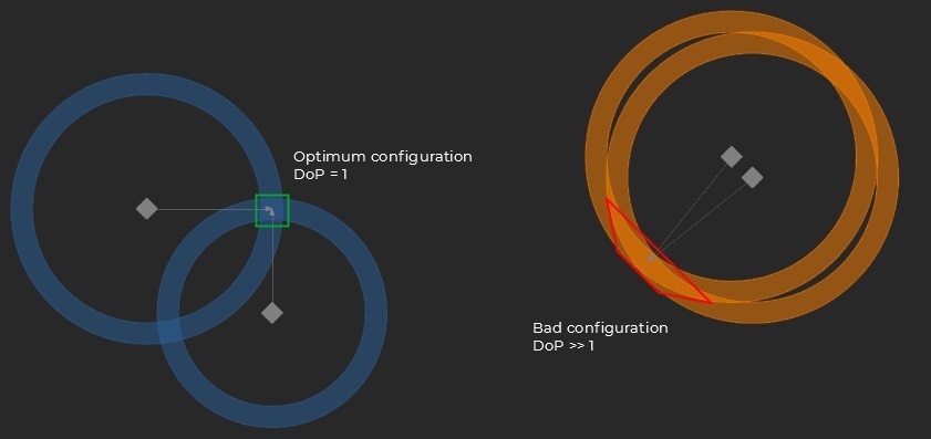
Dilution of Precision

The effective SPS accuracy depends on the conformation of the constellation as seen from the receiver. Intuitively the more “at right angles” the satellites are and the better the accuracy. The phenomenon is called dilution of precision and is expressed as a multiplier on the nominal accuracy: εPNAV,SPS = DoP x [Nominal SPS accuracy]

SRPS / LRPS

SPS signals on the “Short Range” SRPS (UHF, 200 W) and “Long Range” LRPS (SHF, 2 kW) channel sets are compatible. 

At equipped terrestrial planets it is generally possible to compute the position using a single comms slot at low gain (many satellites being in range with this setting).
On the other hand the larger distances at gas and ice giants usually require the targeting of individual satellites at high RX gain.

Celestial Navigation

Whenever it is not in range of SPS constellations the ship has to rely on natural objects to compute its position, more specifically: pulsars.

X-Ray Pulsar Receivers (XPR)

  • Nominal accuracy: 200 m rms
  • Integration time constant: 3000 s
  • Effective range: ∞

The x-ray signals emitted by pulsars exhibiting a highly-regular short period (< 40 milliseconds) can be used to triangulate a position, in a way that is very similar to SPS. The CSN-F9 carries three sets of x-ray telescopes dedicated to that purpose. The selection of the best sources at a given location and time is automatic.
However the signals from far away pulsars can be faint, heavily distorted, and are obviously not optimized for optimum synchronization. As a result a significant integration time (several hours) is required to filter out the noise and achieve the nominal precision.
Part of that learning process is invalidated by jumps due to the variations in the pulsar signals between the departure and the destination. As a result the accuracy of the XPRs is degraded after a jump until they have converged on the new configuration again.

Star Trackers

The ship’s attitude information is provided by optical scanners that use the surrounding star field as reference. They are technically part of the XPR units, and deliver their high-precision orientation signal immediately after powering-up.

Inertial Navigation Units (INU)

Dead Reckoning

  • Nominal accuracy: 35 m / hour after calibration

The INUs feature high-precision accelerometers and laser gyroscopes for all 6 degrees of freedom of the ship’s motion (3 translations, 3 rotations). The sensed data is then continuously integrated to infer the ship’s current state (position, velocity, attitude) without the need for an external reference. The technique is called dead reckoning.

The motion sensors are not perfect and exhibit systematic biases. To prevent a resulting rapid accumulation of large errors in the integration process the sensors need to be calibrated. During this phase the systematic errors are measured against a reference source so as to be mathematically cancelled during normal operations. The more accurate the source, the better. The calibration is triggered automatically whenever a positioning signal is available and is estimated to be more accurate than the current stored reference.

Calibrated INU

A steady blue color and the ⯐ symbol indicate a calibrated INU. The calibration index is featured above the button.
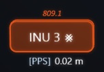
Un-calibrated INU

A blinking blue / amber color and the ⨳ symbol indicate an un-calibrated INU. The calibration index is featured above the button in amber.

The quality of the calibration is figured by the calibration index, which can be interpreted as a multiplier on the nominal drift performance. The calibration data goes stale over time but generally remains valid for multiple days.

Navigation signal aggregation

Besides their dead-reckoning function the INUs are in charge of aggregating the various navigation sources into a single signal that is fed to the flight controller. The operation is performed based on the selected source, and leads to three possible modes:

  • [source]
    The INU is locked to an input signal (PPS, SPS, XPR) whenever its drift is reckoned to be larger than the estimated error from the selected source.
  • → source
    The INU is tracking an input signal whenever the source is valid but exhibits an error that is reckoned to be larger than the current inertial drift. In that mode the output signal is a weighted combination of both the INU’s inertial estimation and  the source signal.
  • Inertial
    The INU remains in dead-reckoning mode as long as no navigation source is available.

The selected source is set by the source selector. In auto mode, the INUs select the signal with best estimated precision.

Finally the flight controller selects the operational INU with best estimated accuracy, and compares all available signals to detect possible malfunctions.

Navigation Systems panel

The Navigation Systems panel is located in the helm station:

The navigation systems are demonstrated in the following video: